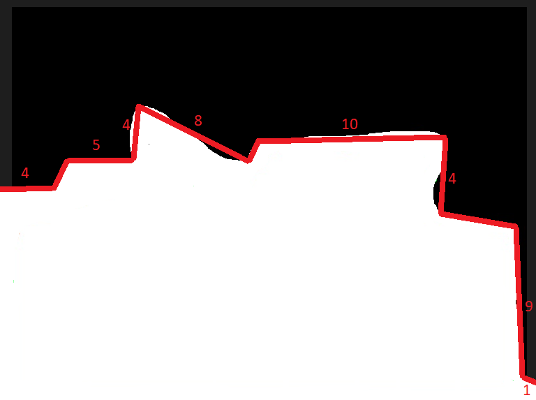
I am very new at Python so what I am trying to do is this:
I already made a mask of floor of given image:
https://i.ibb.co/0r17SnT/www.png
What I want to do is to connect all points by geometric straight lines and find the length of each edge, like I drew on this example:
https://i.ibb.co/tbgyYF5/www.png
I am using openCV, and so far I tried to find some extreme points but it is not what i need i guess.
def getCalculatedImg():

    # Load image
    img = cv2.imread('img.jpg')
    gray_image = cv2.cvtColor(img, cv2.COLOR_BGR2GRAY)

    # Apply cv2.threshold() to get a binary image
    ret, thresh = cv2.threshold(gray_image, 50, 255, cv2.THRESH_BINARY)

    # Find contours:
    contours, hierarchy = cv2.findContours(thresh, cv2.RETR_EXTERNAL, cv2.CHAIN_APPROX_NONE)
    cntrs = contours[0]
    c = max(contours, key=cv2.contourArea)

    # Obtain outer coordinates
    left_coordinates_separated = [(c[c[:, :, 0].argmin()][0])[0], (c[c[:, :, 0].argmin()][0])[1]]
    left = tuple(left_coordinates_separated)
    right_coordinates_separated = [(c[c[:, :, 0].argmax()][0])[0], (c[c[:, :, 0].argmax()][0])[1]]
    right = tuple(right_coordinates_separated)
    top_coordinates_separated = [(c[c[:, :, 1].argmin()][0])[0], (c[c[:, :, 1].argmin()][0])[1]]
    top = tuple(top_coordinates_separated)
    bottom_coordinates_separated = [(c[c[:, :, 1].argmax()][0])[0], (c[c[:, :, 1].argmax()][0])[1]]
    bottom = tuple(bottom_coordinates_separated)

    # Draw contours and dots to image:
    cv2.drawContours(img, [c], -1, (36, 255, 12), 2)
    cv2.circle(img, left, 8, (0, 50, 255), -1)
    cv2.circle(img, right, 8, (0, 255, 255), -1)
    cv2.circle(img, top, 8, (255, 50, 0), -1)
    cv2.circle(img, bottom, 8, (255, 255, 0), -1)
    print('Left point: {}'.format(left))
    print('Right point: {}'.format(right))
    print('Top point: {}'.format(top))
    print('Bottom point: {}'.format(bottom))

    # Output
    cv2.imwrite('outlined_boundered_image.jpg', img)

    return img